Wildfire Prevention Co.’s Holistic Approach to Mitigating Wildfire Risk for Homeowners and Insurance Providers in Texas


October 17, 2025
Regardless of where they occur—Texas, California, or anywhere in between—wildfires of increasing severity continue to shock people year after year. The Smokehouse Creek Fire (February 2024) was the largest fire in Texas history and the 9th largest in U.S. history, yet it was almost immediately overshadowed on the national stage by the L.A. fires (January 2025). The destruction from these fires was a wakeup call to Texans statewide that wildfire is always a threat, even if one lives in a major city. For instance, in 2025, the Austin City Council declared that 51% of the city’s habitable land was at risk of wildfire, up 38% from a decade ago.1 Adding to this anxiety is growing uncertainty surrounding insurance coverage, specifically with cancellations and difficulty sourcing coverage. The good news for home and business owners is that there are several mitigation strategies that will significantly help reduce the risk of losing a property during a wildfire event.
According to Texas A&M Forest Service open records requests, from 2005-2024 there were 245,988 wildfires in Texas, burning a total of 14,041,216 acres. On average, that equates to 12,290 wildfires per year, each burning over 700,00 acres or around 1,090 square miles. For comparison, Houston and San Antonio combined equate to 1,140 square miles of land area. With more frequent and severe fires, these numbers will continue to rise over the next twenty years. In fact, Texas A&M Forest Service lists three main reasons why wildfires will become a more common issue for Texans.2
- Population Growth: Strong economic factors will attract new residents. In 2000, the population of the state was around 20.8 million. By 2020, that number grew to 29.1 million, a 40% growth rate, outpacing the 17% general growth of the U.S. during the same period.
- Land Use: The area where manmade structures interact with undeveloped land is called the Wildland Urban Interface (WUI). According to a 2018 research report, from 1990 to 2010 the WUI grew by 33% in terms of land volume and 41% in terms of new houses, making it the fastest growing land use type in the U.S.3
- Weather Patterns: Camp Mabry in Austin recorded the hottest year on record in 2024 with an average temperature of 72.7°F. This was slightly above 2023’s average, which was the 2nd hottest year on record with an average of 72.3°F. Not only have each of the top 5 warmest years on record happened since 2011, but 9 of the 10 hottest years on record have come since 2000.4
Surprisingly, people have a lot of power when it comes to preventing wildfires. Nearly 90% of wildfires are caused by humans.5 Knowing this and considering the growing population along with the increased contact with WUI areas, the formula for increased risk becomes clear:
More people
+
More housing near wildland
+
Changing/intensifying weather patterns
=
More wildfires
Navigating these complex issues as a homeowner can be challenging, and the potential consequences of not addressing them include loss of insurance coverage and risk of home loss due to wildfire. However, homeowners are overwhelmed with outdated information and misinformation. Even fire departments have differing strategies for wildfire mitigation from station to station. Wildfire Prevention Co. (WPC) creates clarity for our customers by providing detailed risk assessments which use a combination of historical wildfire information, site specific data, and boots-on-the-ground evaluations, and offering a step-by-step plan to reduce risk.
Studies from the U.S. Forest Service have proven that every $1 spent on wildfire mitigation education alone can save an average of $35 in wildfire suppression expenditures and damages.6 Simply by educating our clients on their individual wildfire risk, the state will see savings through altered behavioral patterns and taking active steps to mitigate risk. We have found that learning about individual wildfire risk is an impassioning experience for many homeowners and that knowing what to look for gives them a sense of confidence and security.
Below is a breakdown of how WPC helped a homeowner address his neighborhood’s wildfire risk in the face of a combative HOA.
Project Background:
After the Crabapple Fire in March 2025, CUSTOMER A, a resident from Blanco County, reached out after recognizing similarities in the environmental conditions in his subdivision and where the fire had occurred near Fredericksburg.
CUSTOMER A was informed about basic vegetation management, but his HOA did not have any covenants to enforce property maintenance. Many lots in his neighborhood sat vacant and overgrown for years. He determined that the first step in improving his neighborhood’s safety would be to have a risk assessment conducted on the entire neighborhood, but he could only find sources to conduct risk assessments on one home at a time.
WPC stepped in and agreed to the following scope:
- Evaluate the wildfire risk in the neighborhood using fact-based evidence
- Identify ways to protect homes, residents, infrastructure, and emergency responders fighting wildfires
- Support healthy ecosystems and natural resources
- Educate residents on wildfire preparedness and prevention
Project Methodology:
To evaluate the neighborhood’s true fire risk, WPC reviewed ~1,000 acres in total, encompassing the approximately 200-acre development, an adjacent neighborhood, and surrounding wildland.
By first gathering context about the broader county and environment, we discovered underlying conditions which could contribute to wildfire ignitions or more severe wildfires. We looked at factors included the following:
- Population Growth: The population of Blanco County grew from 8,418 in 2000 to 13,358 in 2024. This represents a 59% growth from 2000-2024.
- Fire Departments/Emergency Service Districts: There are three main entities responding to emergencies in Blanco County. The closest fire department to the subject site is a ~10-minute drive time.
- Climate:
- Red Flag Days: This type of warning issued by the National Weather Service forecasts perfect conditions for wildfire. Between 2022 and 2023, there were almost 50 warnings in this region, well above the annual average (12 per year). In the spring of 2025, there had already been 8 red flag warnings.
- Land Surface Temperatures: Land surface temperatures on the site peak at 130°F in extreme cases, priming the vegetation for ignition.
- Drought Monitoring: Blanco County frequently experiences drought. Both 2022 and 2023 saw a yearly average Drought Severity and Coverage Index above 400 (a value of 0 means the area is not in drought, whereas 500 means that the entire area is experiencing exceptional drought).
We also researched the neighborhood and the historic fire activity in the area.
- Neighborhood Description: ~30 lots spanning ~200 acres, over 6 acres per lot.
- Ingress/Egress: Only one main entrance with a fence surrounding the entirety of the neighborhood. Residents believed that there were two emergency egress routes, however both indicated sites were overgrown and not marked.
- Fires in and around Blanco County: Since 2005, there have been 764 wildfires in Blanco, burning 21,795 acres. Including Blanco’s adjacent counties, there have been 7,712 wildfires, burning 132,974 acres.
- Number of “Major” Fires (100+ Acres) in and around Blanco County: Since 2005, there have been 36 (5% of all fires) major wildfires in Blanco, burning 14,872 acres (68% of all acres burned). Including Blanco’s adjacent counties, there have been 195 major wildfires (3% of all fires), burning 100,615 acres (76% of all acres burned). The closest major fire to the site burned over 500 acres.
- Number of Utility Fires in and around Blanco County: Since 2005, there have been 38 utility-born fires in Blanco, burning 450 acres. Including Blanco’s adjacent counties, there have been 230 utility-born fires, burning 3,226 acres.
To supplement the historic information gathered about Blanco County, the WPC team utilized remote sensing data over a multiyear period to gain detailed information on the type and condition of the vegetation at the 1,000-acre site, and to locate specific areas within the site that have historically been at a higher risk than others. WPC reviewed the following metrics to help inform us on specific fire risks:
- Vegetation Composition: Texas A&M Forest Service offers vegetation classification for Texas. By understanding the vegetation composition, we can better understand how it will react to wildfire and contribute to starting a wildfire.


- Topography: Elevation is important in remote sensing analysis for wildfire risk since fire climbs to higher elevations at a faster rate than it would spread on flat ground. Thus, homes on peaks or at the top of canyons are at greater risk from wildfire.


- Normalized Difference Vegetation Index: The Normalized Difference Vegetation Index (NDVI) measures the greenness and density of the vegetation captured in a satellite image. Its practical applications include identifying vegetation health.


- Normalized Difference Moisture Index: The Normalized Difference Moisture Index (NDMI) detects moisture levels in vegetation and is a reliable indicator of water stress in vegetation. Dry conditions in fire-prone areas increase the risk of combustion.


- Energy Release Component: The Energy Release Component is a number related to the available energy within the flaming front at the head of a fire. This number represents the potential heat release in any given area in the flaming zone and can provide predictive services for several important fire activities.
Lastly, the WPC team utilized a visual, boots-on-the-ground approach to verify information gained from our remote sensing analysis and to see first-hand the vegetation density, ingress/egress paths, and maintenance of individual lots.


Example of Savanna Grassland. Dead grass roughly 2-3’ tall beneath shrubs. A classic example of substantial amount of fuel leading to extreme fire risk


Dense vegetation beneath larger stand of Ashe Juniper and Oak trees, also considered ladder fuels


A well-maintained lawn with firewood underneath mature oak trees.


The well maintained, wide roadways of the neighborhood with well-maintained vegetation.


Dead/dying grassland underneath larger vegetation, with house in the background. House likely in threat from fuel load.


Heavy fuel loads with house in the background.
Results:
The data pulled for the WPC report showed the following information:
- Texas and Blanco County have and will continue to have higher temperatures and more days of extreme heat on average
- Texas and Blanco County will continue to experience more frequent Red Flag Days on average
- Blanco County experiences frequent drought conditions, leading to fuels dying and drying out
- Vegetation endemic to the county is susceptible to drought conditions
- The county has a strong history of large wildfires, including a 680-acre fire less than 1.2 miles from the neighborhood entrance
- A record of utility-born fires in the area
Additionally, our field work showed several vacant lots within 200 feet (the outer parameters of the Home Ignition Zone) of homes with concerning vegetation accumulation and ladder fuels (i.e. grass accumulation underneath trees, propagating fire spread from grass to trees). Overall, while most residents maintained their yards and the roads were well-maintained, there was a concerning level of tall, thick grass surrounding large trees or brush throughout the neighborhood. The primary risk is that a large, advancing fire could throw embers into the thick brush and create spot fires, or a homeowner could accidently start a fire near their home which could quickly get out of control. 90% of homes in any given wildfire event burn due to ember cast in similar scenarios, thus most of the homes in this neighborhood could be at risk if no mitigation actions were taken.
Home within 200 feet of lot where dense vegetation appears to grow or is likely to grow


NDVI pulled 4/8/2025 showing same home adjacent lot with low to moderate vegetation health (darker green coloration), with pockets of unhealthy vegetation (lighter green to tan coloration).


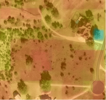
NDMI pulled 4/8/2025 showing same home and adjacent lot having critical levels of dry vegetation (yellowish/orange to red coloration).
Recommendations:
To reduce risk, WPC recommends the following mitigation strategies:
- Home hardening for individual homes:
- Immediate Zone: Each home and the area 0-5 feet from the furthest attached exterior point of the home; defined as a non-combustible area. Examples of mitigation in this zone:
- Add ember resistant vents / ember resistant mesh
- Clean gutters to remove dead leaves
- Move flammable material away from wall exteriors (i.e. mulch or decorative plants)
- Intermediate Zone: 5-30 feet from the furthest exterior point of the home. Landscaping / hardscaping to create breaks that decrease fire behavior. Examples of mitigation in this zone:
- Mow lawns and native grasses to a maximum height of 4 inches
- Remove ladder fuels to prevent crown fires from spreading
- Prune trees 6 to 10 feet from the ground, or 1/3 the overall tree height
- Remove tree canopy that is within 10 feet of any existent structure
- Extended Zone: 30-200 feet. Landscaping – the goal here is to interrupt the path of fire and keep flames smaller and on the ground. Examples of mitigation in this zone:
- Remove dead vegetation or trees
- Remove small trees growing between mature trees
- Dispose of heavy accumulations on the ground
- Immediate Zone: Each home and the area 0-5 feet from the furthest attached exterior point of the home; defined as a non-combustible area. Examples of mitigation in this zone:
- Firebreaks:
- Clear a 20-foot-wide perimeter around the neighborhood down to bare soil
- Add more firebreaks inside the community
- Road Maintenance:
- Mow and clear grass along the main road frontage
- Trim trees with low-hanging limbs to reduce ignition risks along the main road frontage and allow better access for emergency vehicles
- Landscaping Rules:
- Actively enforce landscaping and property maintenance requirements for all lots within the neighborhood
- All dead and downed vegetation should be regularly removed
- All ladder vegetation under mature trees should be removed and regularly cut back. Savanna Grasslands should be regularly cut down
- Emergency Planning:
- Clear and maintain at least two emergency evacuation routes and ensure they are well-known and clearly marked. Ensure any car and first responders can traverse these routes
- Firefighting Resources:
- Invest in tools and train personnel for quick deployment (e.g., trucks with sprayers or sprinkler systems designed to spray fire retardant)
- Community Action:
- Join the Firewise USA® program (https://www.nfpa.org/education-and-research/wildfire/firewise-usa/become-a-firewise-usa-site)
Conclusion:
Ultimately, the HOA listened to the advice of WPC and is working to form covenants which would assist homeowners in mitigating their wildfire risk on a go forward basis.
About Wildfire Prevention Co.
Wildfire Prevention Co. (“WPC”) is Texas’ first full-service wildfire mitigation company based in Hays County. WPC was established with the singular goal of safeguarding communities against the ever-growing threat of wildfire through prevention, protection, and mitigation efforts.
The WPC team has a combined 60+ years in business operations, leadership, and executive management roles. Additionally, the WPC team works with individuals with 40+ years of wildfire fighting and mitigation expertise.
WPC offers a complete range of services and products intended to help clients prevent and recover from wildfires and is engaged with key governmental entities and critical business providers across the state to help make all of Texas safer.
Our services include:
- Large property / neighborhood risk assessments
- Individual home risk assessments
- Home hardening (such as ember resistant vent installation and landscaping within the first 30’ of a home)
- Tree service and land work
- Fire recovery efforts (reseeding / hydroseeding)
- Exclusive distributor / service provider of PHOS-CHEK® long-term fire-retardant in Texas
Alex Foster
Chief Operating Officer at Wildfire Prevention Co.
alex@txwildfire.com
347-622-0225
Sources:
- McGlinchy, A. (2025, April 10). Austin adopts new map that greatly expands area at risk of Wildfire. KUT Radio, Austin’s NPR Station. https://www.kut.org/energy-environment/2025-04-10/austin-tx-wildfire-risk-map-wildland-urban-interface-wui-city-council-vote
- Texas wildfire protection plan. Texas A&M Forest Service. (2025, April 17). https://tfsweb.tamu.edu/TWPP/
- Rapid growth of the US wildland-urban interface raises ... (2018, March 12). https://www.pnas.org/doi/full/10.1073/pnas.1718850115
- Darensbourg, J. (2024, December 31). 2024 ends as warmest on record for Camp Mabry | kvue.com. https://www.kvue.com/article/weather/2024-warmest-on-record/269-357512a1-eb71-4184-a563-c5e9c1a0e3f4
- What causes wildfires?. Western Fire Chiefs Association. (2024, March 4). https://wfca.com/wildfire-articles/what-causes-wildfires/
- Butry, David T.; Prestemon, Jeffrey P. 2019. Economics of WUI/Wildfire Prevention and Education. In: Manzello, S.L. (Ed.) Encyclopedia of Wildfires and Wildland-Urban Interface (WUI) Fires. Springer, Cham, Switzerland. 8 pages.
